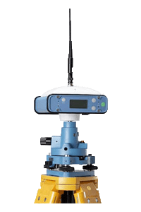
STAR S86
Advanced technology of data link
Optimized 3-proof design
Powerful field application software
Complete cable-free design
Built-in transmitting radio
Various modules optional
Optimized 3-proof design
Powerful field application software
Complete cable-free design
Built-in transmitting radio
Various modules optional
Product Feature
ROVER
- Dual frequency receiver S86
- Charger for S86
- 450MHz UHF all-direction antenna
- Multifunction communication cable
- Receiver-controller cable
- Controller: PSION
- Controller battery
- Charger for controller battery
- Carbon fibre pole
- Bracket
- Connector
- Plummet & tribrach
- SD card & reader
- Measuring tape
- HI measuring plate
- Carrying case & soft bag
BASE STATION
- Dual frequency receiver S86
- Charger for S86
- 450MHz UHF all-direction antenna
- Plummet & tribrach
- Connector
- Measuring tape
- HI measuring plate
- Carrying case & soft bag
OPTIONAL
- 6.5db UHF all-direction antenna
- External radio 0.5W/2W or 2W/5W or 15W/25W
- Charger for radio
- External radio cable
- Power/data cable
Field Software: Engineering star
- Store points
- Stake out points, line, arc, spiral
- Road design and staking out
- Electrical wire reconnaissance survey
- Powerful COGO utilities
Technical Specification
- Channel: 24 channels, L1/L2, C/A
- Static horizontal accuracy: 3mm+1ppm
- Static vertical accuracy: 10mm+1ppm
- Static work range: ≤100km
- Memory: built-in 32M
- RTK horizontal accuracy: 10mm+1ppm
- RTK vertical accuracy: 20mm+1ppm
- RTK work range: ≤8km
- Communication: USB, Bluetooth, serial port
- Data link: 0.5w/2w (transmitting power)
- RTK initialization time: typically 15 seconds
- Size (LxWxH): 154x154x88mm
- Weight: 1.35kg
- Working temperature: -30°C ~ 65°C
- Storage temperature: -40°C ~ 85°C
- Waterproof and dustproof
- Built-in double lithium batteries packages
- Working time: 15 hours to 20 hours(full)
- Charge time: 9 hours
- Power: <1.8W
- External power supply: 10V ~15V DC
- Charging voltage:110~240V AC
Accuracy and reliability may be subject to anomalies such as multipath, obstructions, satellite geometry and atmospheric conditions. Always follow recommended survey practices.